Recent Gallery


Tampilkan postingan dengan label Impossible Places. Tampilkan semua postingan

Nordlingen - The town inside a meteorite crater

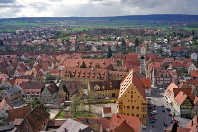
The town of Nordlingen in the Donau-Ries district of Bavaria, Germany, is unlike any other town in the district. In fact, it's unlike any other town on the whole planet. This pretty medieval town, with a population of 20,000, is situated entirely inside a massive meteorite crater 25 km across. This crater called the Nördlinger Ries, was formed some 14.5 million years ago when a meteor about a mile across slammed into Earth. It was only less than fifty years ago that evidence emerged which established the true origin of this town.

Nordlingen (2)
Nordlingen (4)
Nordlingen - for centuries unsuspecting people have been living inside a crater


Nordlingen (3)
Aerial view of the town. The crater rim distinctly visible

Ries_Crater_Rim
This hill is actually the rim of the crater

For years, it was believed that the shallow depression in the middle of which the town is situated was a volcanic crater. Then in 1960 two American scientists, Eugene Shoemaker (of comet Comet Shoemaker-Levy 9 fame) and Edward Chao, proved that the depression was in fact, caused by meteorite impact. While visiting a church in the town of Nordlingen, Shoemaker reportedly scratched its walls to see what it was made of and was delighted to discover shocked quartz, a type of rock that can only be formed by the shock pressures normally associated with meteorite impact. Subsequent exploration of the strange rock formations of the Ries conclusively established that the crater was caused by a meteor impact.
Nordlingen-panaromic
Panaromic view of the town. The hill on the distant is the rim of the crater
There is another impact crater the Steinheim crater, about 3.8 km in diameter,  located about 42 kilometers west-southwest from the centre of Ries. These two craters are believed to have formed nearly simultaneously by the impact of a binary asteroid.

Image sources: 1,2,3,4,5

8 of the Most Dangerous Places (To Live) on the Planet

8 of the Most Dangerous Places (To Live) on the Planet

It’s hurricane season, a time of year when residents in vulnerable areas—like New Orleans—need to hunker down, stock up and prepare for the unforeseen. But there are other places in the world where the dangers are so great that it’s hard to believe anyone is willing to stay put and fight it out with Mother Nature. Here, we have canvassed the globe for 10 places that require fortitude, resourcefulness and a great faith in one’s DIY skills to make it through the year alive.


The Cold Pole

Verkhoyansk, Russia
The Cold Pole
A monument reading "Polyus Cholada," Russian for "Pole of Cold," stands at the entrance to the city of Verkhoyansk.

On the frigid taiga, 3000 miles east of Moscow, deep in the heart of Siberia, sits Verkhoyansk, the oldest city above the Arctic Circle. For more than three centuries, Russians have continuously resided here, braving endless winters on the banks of the Yana River, which is frozen solid for nine months of the year. Today, approximately 1500 people live here.

Verkhoyansk lays claim to the title of coldest city in the world, the so-called Cold Pole. It's hard to dispute the designation, when you consider that from September to March the city averages fewer than 5 hours of sunlight each day. (In December and January, there is nearly no sunlight.) Winter temperatures there typically fall between minus 60 and minus 40 degrees Fahrenheit. The low, recorded in the late 19th century, was minus 90.

Nowadays, the city is attempting to attract "extreme tourists," who are drawn by the intense cold. For much of its history, however, Verkhoyansk was a preferred exile destination, used first by the czars, then later by the Soviets. In the 20th century, Verkoyansk's population peaked at 2500 residents.

The Mountain of Fire

Mount Merapi, Indonesia
The Mountain of Fire
A woman pushes a cart as the Mount Merapi volcano emits smoke. (Photograph by Tarko Sudiarno/AFP/Getty Images)
Even during its most tranquil periods, Mount Merapi, on the island of Java, smolders. Smoke ominously floats from its mouth, 10,000 feet in the sky. "Fire Mountain," as its name translates to English, has erupted about 60 times in the past five centuries, most recently in 2006. Before that, a 1994 eruption sent forth a lethal cloud of scalding hot gas, which burned 60 people to death. In 1930, more than 1000 people died when Merapi spewed lava over 8 square miles around its base, the high death toll being the result of too many people living too close.

In spite of this volatile history, approximately 200,000 villagers reside within 4 miles of the volcano. But Merapi is just one example of Javans tempting fate in the proximity of active volcanoes—it's estimated that 120 million of the island's residents live at the foot of 22 active volcanoes.

Haiti's Perfect Storms

Gonaves, Haiti
Haiti's Perfect Storms
Debris litters a street in Gonaïves in the aftermath of hurricanes Hannah and Ike. (Photograph by Roosewelt Pinheiro/Agencia Brasil)

First came tropical storm Fay on August 16. A week later, Hurricane Gustav blew through. Following in quick succession were Hurricanes Hanna and Ike. In the span of just one month, the coastal city of Gonaïves, one of Haiti's five largest cities, found itself on the receiving end of four devastating tropical cyclones. When the last storm passed, Gonaïves had practically been washed out to sea. Much of the city was buried under mud, or submerged in filthy water that stood 12 feet deep in some places. The death toll ran close to 500.

But the storms of August to September 2008 weren't the most deadly in Gonaïves' recent history. In 2004, the city of 104,000 took a severe beating from Hurricane Jeanne. Three thousand Haitians died when the Category 3 storm hit and leveled large swaths of the city.

What makes Gona¯ves so susceptible to destruction by hurricane? Aside from its coastal location on the Gulf of Gonve, smack-dab in the cyclone-inclined Caribbean, Gonaïves rests on a flood plain prone to washing out when inland rivers swell. Furthermore, Haitians rely on wood to make charcoal, their primary source of fuel, and this has led to massive deforestation of the hillsides surrounding the city. As a result, when the rains come, the hills around Gonaïves melt away and mudslides nearly bury the city.

The African Lake of Death

Lake Kivu, Democratic Republic of Congo/Rwanda
The African Lake of Death
Steam rises from Lake Kivu as lava from a nearby volcano spills into the water. (Photograph by Pedro Ugarte/AFP/Getty Images)

Lake Kivu, located along the border between the Democratic Republic of Congo and Rwanda, is one of Africa's Great Lakes. Deep below the surface of this lake's 2700 square miles, there are 2.3 trillion cubic feet of methane gas, along with 60 cubic miles of carbon dioxide trapped beneath the lake under the pressure of the water and earth. If released from the depths, these gases could spread a cloud of death over the 2 million Africans who make their home in the Lake Kivu basin.

The precedent for this concern stems from a pair of events that occurred in the 1980s at two other African lakes with similar chemical compositions. In 1984, 37 people died around Cameroon's Lake Monoun in a limnic eruption. Three years later, at Lake Nyos, also in Cameroon, 80 cubic meters of CO2 were released from the water. Subsequently, 1700 people died from exposure to the toxic gas. These incidents were apparently caused by volcanic activity below the lakes, which triggered the release of the gas. Similar activity is believed to occur beneath Lake Kivu, causing many to worry that this area is next. A report from the United Nations' Environmental Program went so far as to call the three bodies "Africa's Killer Lakes," and said Lake Kivu was cause for "serious concern."

The Ephemeral Isles

The Maldives
The Ephemeral Isles
A Maldivian man looks at the sea in Male. (Photograph by Pedro Ugarte/AFP/Getty Images)

The Maldives are such a dangerous place that Muhammed Nasheed, upon taking office in 2008, made it one his first items of business as the Maldives' first democratically elected president to announce a plan to create a fund for financing the relocation of the entire population.

The Maldives is a confederation of 1190 islands and atolls in the Indian Ocean. Its highest point of elevation is little more than 6 feet, and, sometime in the not-too-distant future, it is likely to be swallowed whole by rising sea levels. A 2005 assessment by the United States Geological Survey, conducted after the 2004 Indian Ocean tsunami, called the Maldives one of the Earth's youngest land masses, adding that they're not long for life above water. According to the report, the islands "should be considered ephemeral features over geologic time."

By President Nasheed's reckoning, the people of the Maldives would be well-served to find someplace else—India or Sri Lanka were floated as potential refuges—lest they too become ephemeral. Recent events support his decision to invest money earned through tourism in a relocation fund: The 2004 tsunami, which occurred at low tide, swept over the island, leaving 10 percent of the country uninhabitable. Of the Maldives' 300,000 citizens, one-third were left homeless, and more than 80 people died. In 1987, during so-called "king tides," the capital of Malé, an island city covering 1 square mile, was completely inundated. The effects of these disasters were compounded by the mining of the coral reefs that surround the islands, which has made them highly susceptible to sea erosion.

Hurricane Capital of the World

Grand Cayman
Hurricane Capital of the World
The MODIS instrument aboard NASA's Aqua satellite captured this true-color image of Hurricane Ivan as the eye passed of Grand Cayman on September 13, 2004. (Photograph by NASA)

The Cayman Islands, a British territory situated 150 miles south of Cuba, are best known as a tropical playground for the champagne and caviar set, who come to the islands for pristine Caribbean beaches, world-class diving, and lax banking regulations. Less alluring is the islands' other reputation as "hurricane capital of the world." According to the tropical-storm-tracking website hurricanecity.com, Grand Cayman, the largest of the three Cayman isles, is hit or brushed by at least one hurricane every 2.16 years, more than any other locale in the Atlantic basin. Since 1871, 64 storms have battered the low-lying limestone formation, often with catastrophic results.

In 2004, Hurricane Ivan, a Category 5 storm with wind speeds approaching 150 miles per hour, dumped a foot of rain on Grand Cayman. A 10-foot storm surge followed, submerging a quarter of the island. An estimated 70 percent of the island's buildings were destroyed, and its 40,000 inhabitants were left without power or clean water for days.

The I-44 Tornado Corridor

Oklahoma City/Tulsa, Oklahoma
The I-44 Tornado Corridor
A girl sits with her dog at a motel damaged by a tornado in Moore, Oklahoma. (Photograph by David McNeese/Getty Images)

More than 1 million people reside along the Interstate 44 corridor that runs between Oklahoma City and Tulsa, the Sooner State's two most populous metropolitan areas. Each spring, as the cool, dry air from the Rocky Mountains glides across the lower plains, and the warm, wet air of the Gulf Coast comes north to meet it, the residents of this precarious stretch, locally called Tornado Alley, settle in for twister season.

Since 1890, more than 120 tornados have struck Oklahoma City and the surrounding area, which currently has a population of approximately 700,000. On May 3, 1999, an outbreak of 70 tornados stretched across Oklahoma, Kansas and Texas. Several of the most destructive storms swept through Oklahoma City, destroying 1700 homes and damaging another 6500. Even with modern prediction capabilities and early-warning systems, 40 people died when an F-5 twister tore through Oklahoma City. In addition to the loss of life, this display of natural devastation caused more than $1 billion in damage. Since 1950, the longest the area has gone without a tornado is five years—from 1992 to 1998. (As if making up for lost time, in the 11 months that followed that record lull, 11 tornados hit.) For only three other periods during the last half-century has Oklahoma City gone more than two years without a tornado.

Northeast of Oklahoma City, along the same track that most tornado-producing storms travel, sits Tulsa, which has experienced its own share of devastation at the hands of Tornado Alley's storms. Between 1950 and 2006, 69 tornados spun across Tulsa County—population 590,000—though none proved as deadly as the 1999 storm that hit Oklahoma City. But because of its geography—the city lies along the banks of the Arkansas River and is built atop an extensive series of creeks and their flood plains—Tulsa is particularly vulnerable to the rain that accompanies Oklahoma's severe weather. Major floods in 1974, 1976 and 1984 caused hundreds of thousands of dollars worth of damage.

China's Creeping Sandbox

Minquin County, China
China's Creeping Sandbox
A man wipes his forehead while trying to work in a sand storm on a street in Minqin County, Gansu province, China. (Photograph by ChinaFotoPress/Getty Images)

Trapped between two creeping deserts, the once fertile oasis of Minqin County, in northwest Gansu province, lives on borrowed time. The double whammy of a decade-long drought and the upriver diversion of water from its lifeline, the Shiyang River, have left Minqin to wither into the Tengger desert, which approaches from the southeast, and the Badain Jaran, closing in from the northwest. In total, since 1950, the deserts have swallowed up more than 100 square miles. During that same period, the population there has risen from 860,000 to more than 2 million.

As of 2004, the deserts were approaching at a rate of 10 meters per year. With more than 130 days of wind and dust each year, that rate is unlikely to slow. Faced with rapid desertification, the Chinese government has begun relocating displaced farmers, as arable land has decreased from 360 square miles to fewer than 60.

The 15 most toxic places to live

The 15 most toxic places to live-Vapi, India
Sitting at the southern end of a 400-kilometer-long belt of industrial estates, the town of Vapi is a dumping place for chemicals of every kind. Levels of mercury in the groundwater are 96 times higher than safety levels, and heavy metals are present in the air and the local produce
Vapi, India
CREDIT: Greenpeace/Shailendra Yashwan


The 15 most toxic places to live-Dzerzhinsk, Russia
The Guinness Book of World Records has named Dzerzhinsk the most chemically polluted city on Earth, and in 2003 its death rate exceeded its birth rate by 260 percent. More than 300,000 tons of chemical waste were improperly dumped here between 1930 and 1998.
Dzerzhinsk, Russia
CREDIT: Spendruleziya/Flickr

The 15 most toxic places to live-Riachuelo Basin, Argentina
The Riachuelo Basin is a waterway whose name is synonymous with pollution. More than 3,500 factories operate along the banks of the river, a landscape that also includes 13 slums, numerous illegal sewage pipes running directly into the river, and 42 open garbage dumps.
Riachuelo Basin, Argentina
CREDIT: FJTU/Flickr

The 15 most toxic places to live-Earth's orbit
Believe it or not, even space contains copious amounts of pollution. An estimated 4 million pounds of space debris — nuts, bolts, metal and carbon, even whole spacecraft — currently orbit the Earth, threatening satellites, communication and even the lives of our astronauts.
Earth's orbit
CREDIT: European Space Agency

The 15 most toxic places to live

The 15 most toxic places to live-Haiti
The nation of Haiti was once 60 percent covered in forest. Today, only 2 percent of the country still has standing trees. This picture shows an aerial of the border between Haiti (left) and the Dominican Republic (right). Haiti has cleared almost every tree right up to its borders. And with the recent devastating earthquake, the island's environmental situation has worsened.
Haiti
CREDIT: National Geographic Society/James P. Blair

The 15 most toxic places to live-Lake Karachay, Russia
According to a report by the Worldwatch Institute on nuclear waste, Karachay is the most polluted spot on Earth. It was used by the Soviet Union as a nuclear dumping site, and now the radiation level here is so high that it's sufficient to give a lethal dose after just an hour of exposure.
Lake Karachay, Russia
CREDIT: Yuri Kadobnov/AFP/Getty Images

The 15 most toxic places to live-Kabwe, Zambia
Lead and cadmium soak the hills of Kabwe after decades of mining and processing. Children here have lead concentrations five to 10 times the permissible U.S. Environmental Protection Agency levels, and the ground is so contaminated that nothing can be grown.
Kabwe, Zambia
CREDIT: Blacksmith Institute

The 15 most toxic places to live-Appalachia, West Virginia
Mountaintop removal mining is one of the world's most environmentally destructive practices, and it is most associated with coal mining in West Virginia's Appalachian Mountains. Whole mountaintops are removed to get to the coal, which increases erosion and runoff thick with pollutants, poisoning streams and rivers throughout the region.
Appalachia, West Virginia
CREDIT: AP Photo/Jeff Gentner

The 15 most toxic places to live

The 15 most toxic places to live-Apocalypse now?
As the world's population balloons to almost 7 billion, it's become more and more difficult to find anywhere on Earth unaffected by man-made pollution and development, and far too often it takes things going really wrong before people take action to keep our planet clean. So here's a list that might help to motivate: The 15 most polluted places in the world.
Apocalypse now?


The 15 most toxic places to live-Linfen, China
Linfen has more air pollution than any other city in the world. Sitting at the heart of China's coal belt, smog and soot from industrial pollutants and automobiles blacken the air at all hours. It is said that if you hang your laundry here, it will turn black before it dries.
Linfen, China


The 15 most toxic places to live-Rondônia, Brazil
Rondônia is a state in northwest Brazil which, along with the states of Mato Grosso and Pará, is one of the most deforested regions of the Amazon rain forest. Thousands of acres of forest have been slashed and burned here, mostly to make room for cattle ranching.
Rondônia, Brazil
CREDIT: National Geographic/Getty Images

The 15 most toxic places to live-The North Pacific Gyre
An island of trash twice the size of Texas floats in the middle of the Pacific Ocean, circulated by the currents of the North Pacific Gyre. The trash, which is mostly made up of plastic debris, floats as deep as 30 feet below the surface.
The North Pacific Gyre
CREDIT: Cesarharada.com/Flickr

The 15 most toxic places to live

The 15 most toxic places to live-Citarum River, Indonesia

The Citarum has been called the world's most polluted river. Around five million people live in the river's basin, and most of them rely on its flow for their water supply.

Citarum River, Indonesia
CREDIT: EPA

The 15 most toxic places to live-Chernobyl, Ukraine

Chernobyl is the town in northern Ukraine home to the Chernobyl disaster of 1986, the worst nuclear power plant accident in history. Once home to more than 14,000 residents, the town remains mostly uninhabited and unsafe today due to extensive radioactive contamination.

Chernobyl, Ukraine


The 15 most toxic places to live-Yamuna River, India
The Yamuna is the largest tributary of the Ganges River. Where it flows through Delhi, it's estimated that 58 percent of the city's waste gets dumped straight into the river. Millions of Indians still rely on these murky, sewage-filled waters for washing, waste disposal and drinking water.
Yamuna River, India
CREDIT: AFP/Manan Vatsyayan


The 15 most toxic places to live-La Oroya, Peru
La Oroya is a soot-covered mining town in the Peruvian Andes. Ninety-nine percent of the children who live here have blood levels that exceed acceptable limits for lead poisoning, which can be directly attributed to an American-owned smelter that has been polluting the city since 1922.
La Oroya, Peru
CREDIT: Lakerae/Flickr

The Most Impossible Places To Live on the Planet

Popular Mechanics wrote an article of the Most Dangerous Places To Live on the Planet. But I figured I could still take it one step further.

8 Most Dangerous Places to Live on the Eart

Here’s the most dangerous places to live in the world. People sometime living in the places that have high risk to their life. So here’s some of the places that categorizes with dangerous for human to live.


8. China’s Creeping Sandbox: Minquin County, China

Minquin County China
Trapped between two creeping deserts, the once fertile oasis of Minqin County, in northwest Gansu province, lives on borrowed time. The double whammy of a decade-long drought and the upriver diversion of water from its lifeline, the Shiyang River, have left Minqin to wither into the Tengger desert, which approaches from the southeast, and the Badain Jaran, closing in from the northwest. In total, since 1950, the deserts have swallowed up more than 100 square miles. During that same period, the population there has risen from 860,000 to more than 2 million.

As of 2004, the deserts were approaching at a rate of 10 meters per year. With more than 130 days of wind and dust each year, that rate is unlikely to slow. Faced with rapid desertification, the Chinese government has begun relocating displaced farmers, as arable land has decreased from 360 square miles to fewer than 60.
7. The I-44 Tornado Corridor: Oklahoma City/Tulsa, Oklahoma

Oklahoma Tulsa USA
Oklahoma Tulsa USA
More than 1 million people reside along the Interstate 44 corridor that runs between Oklahoma City and Tulsa, the Sooner State’s two most populous metropolitan areas. Each spring, as the cool, dry air from the Rocky Mountains glides across the lower plains, and the warm, wet air of the Gulf Coast comes north to meet it, the residents of this precarious stretch, locally called Tornado Alley, settle in for twister season.
Since 1890, more than 120 tornados have struck Oklahoma City and the surrounding area, which currently has a population of approximately 700,000. On May 3, 1999, an outbreak of 70 tornados stretched across Oklahoma, Kansas and Texas. Several of the most destructive storms swept through Oklahoma City, destroying 1700 homes and damaging another 6500. Even with modern prediction capabilities and early-warning systems, 40 people died when an F-5 twister tore through Oklahoma City. In addition to the loss of life, this display of natural devastation caused more than $1 billion in damage. Since 1950, the longest the area has gone without a tornado is five years—from 1992 to 1998. (As if making up for lost time, in the 11 months that followed that record lull, 11 tornados hit.) For only three other periods during the last half-century has Oklahoma City gone more than two years without a tornado.
6. Hurricane Capital of the World: Grand Cayman

Cayman island
Cayman island
The Cayman Islands, a British territory situated 150 miles south of Cuba, are best known as a tropical playground for the champagne and caviar set, who come to the islands for pristine Caribbean beaches, world-class diving, and lax banking regulations. Less alluring is the islands’ other reputation as “hurricane capital of the world.” According to the tropical-storm-tracking website hurricanecity.com, Grand Cayman, the largest of the three Cayman isles, is hit or brushed by at least one hurricane every 2.16 years, more than any other locale in the Atlantic basin. Since 1871, 64 storms have battered the low-lying limestone formation, often with catastrophic results.
In 2004, Hurricane Ivan, a Category 5 storm with wind speeds approaching 150 miles per hour, dumped a foot of rain on Grand Cayman. A 10-foot storm surge followed, submerging a quarter of the island. An estimated 70 percent of the island’s buildings were destroyed, and its 40,000 inhabitants were left without power or clean water for days.
5. The Ephemeral Isles: The Maldives

The Ephemeral Isles Maldives most dangerous place to live 8 Most  Dangerous Places to Live on the Earth
Maldives
The Maldives are such a dangerous place that Muhammed Nasheed, upon taking office in 2008, made it one his first items of business as the Maldives’ first democratically elected president to announce a plan to create a fund for financing the relocation of the entire population.
The Maldives is a confederation of 1190 islands and atolls in the Indian Ocean. Its highest point of elevation is little more than 6 feet, and, sometime in the not-too-distant future, it is likely to be swallowed whole by rising sea levels. A 2005 assessment by the United States Geological Survey, conducted after the 2004 Indian Ocean tsunami, called the Maldives one of the Earth’s youngest land masses, adding that they’re not long for life above water. According to the report, the islands “should be considered ephemeral features over geologic time.”
By President Nasheed’s reckoning, the people of the Maldives would be well-served to find someplace else—India or Sri Lanka were floated as potential refuges—lest they too become ephemeral. Recent events support his decision to invest money earned through tourism in a relocation fund: The 2004 tsunami, which occurred at low tide, swept over the island, leaving 10 percent of the country uninhabitable. Of the Maldives’ 300,000 citizens, one-third were left homeless, and more than 80 people died. In 1987, during so-called “king tides,” the capital of Malé, an island city covering 1 square mile, was completely inundated. The effects of these disasters were compounded by the mining of the coral reefs that surround the islands, which has made them highly susceptible to sea erosion.
4. The African Lake of Death: Lake Kivu, Democratic Republic of Congo/Rwanda

Kivu lake Congo Rwanda
Lake Kivu, located along the border between the Democratic Republic of Congo and Rwanda, is one of Africa’s Great Lakes. Deep below the surface of this lake’s 2700 square miles, there are 2.3 trillion cubic feet of methane gas, along with 60 cubic miles of carbon dioxide trapped beneath the lake under the pressure of the water and earth. If released from the depths, these gases could spread a cloud of death over the 2 million Africans who make their home in the Lake Kivu basin.
The precedent for this concern stems from a pair of events that occurred in the 1980s at two other African lakes with similar chemical compositions. In 1984, 37 people died around Cameroon’s Lake Monoun in a limnic eruption. Three years later, at Lake Nyos, also in Cameroon, 80 cubic meters of CO2 were released from the water. Subsequently, 1700 people died from exposure to the toxic gas. These incidents were apparently caused by volcanic activity below the lakes, which triggered the release of the gas. Similar activity is believed to occur beneath Lake Kivu, causing many to worry that this area is next. A report from the United Nations’ Environmental Program went so far as to call the three bodies “Africa’s Killer Lakes,” and said Lake Kivu was cause for “serious concern.”
3. Haiti’s Perfect Storms: Gonaïves, Haiti

Gonaives haiti
Gonaives haiti
First came tropical storm Fay on August 16. A week later, Hurricane Gustav blew through. Following in quick succession were Hurricanes Hanna and Ike. In the span of just one month, the coastal city of Gonaïves, one of Haiti’s five largest cities, found itself on the receiving end of four devastating tropical cyclones. When the last storm passed, Gonaïves had practically been washed out to sea. Much of the city was buried under mud, or submerged in filthy water that stood 12 feet deep in some places. The death toll ran close to 500.
But the storms of August to September 2008 weren’t the most deadly in Gonaïves’ recent history. In 2004, the city of 104,000 took a severe beating from Hurricane Jeanne. Three thousand Haitians died when the Category 3 storm hit and leveled large swaths of the city.
What makes Gonaïves so susceptible to destruction by hurricane? Aside from its coastal location on the Gulf of Gonâve, smack-dab in the cyclone-inclined Caribbean, Gonaïves rests on a flood plain prone to washing out when inland rivers swell. Furthermore, Haitians rely on wood to make charcoal, their primary source of fuel, and this has led to massive deforestation of the hillsides surrounding the city. As a result, when the rains come, the hills around Gonaïves melt away and mudslides nearly bury the city.
2. The Mountain of Fire: Mount Merapi, Indonesia

Mount Merapi
Mount Merapi
Even during its most tranquil periods, Mount Merapi, on the island of Java, smolders. Smoke ominously floats from its mouth, 10,000 feet in the sky. “Fire Mountain,” as its name translates to English, has erupted about 60 times in the past five centuries, most recently in 2006. Before that, a 1994 eruption sent forth a lethal cloud of scalding hot gas, which burned 60 people to death. In 1930, more than 1000 people died when Merapi spewed lava over 8 square miles around its base, the high death toll being the result of too many people living too close.
In spite of this volatile history, approximately 200,000 villagers reside within 4 miles of the volcano. But Merapi is just one example of Javans tempting fate in the proximity of active volcanoes—it’s estimated that 120 million of the island’s residents live at the foot of 22 active volcanoes.
1. The Cold Pole: Verkhoyansk, Russia

Verkhoyansk, Russia
Verkhoyansk, Russia
On the frigid taiga, 3000 miles east of Moscow, deep in the heart of Siberia, sits Verkhoyansk, the oldest city above the Arctic Circle. For more than three centuries, Russians have continuously resided here, braving endless winters on the banks of the Yana River, which is frozen solid for nine months of the year. Today, approximately 1500 people live here.
Verkhoyansk lays claim to the title of coldest city in the world, the so-called Cold Pole. It’s hard to dispute the designation, when you consider that from September to March the city averages fewer than 5 hours of sunlight each day. (In December and January, there is nearly no sunlight.) Winter temperatures there typically fall between minus 60 and minus 40 degrees Fahrenheit. The low, recorded in the late 19th century, was minus 90.
Nowadays, the city is attempting to attract “extreme tourists,” who are drawn by the intense cold. For much of its history, however, Verkhoyansk was a preferred exile destination, used first by the czars, then later by the Soviets. In the 20th century, Verkoyansk’s population peaked at 2500 residents.
Taken from http://www.popularmechanics.com/science/earth/4329314.html

Top 10 Most Impossible Places To Visit in the World

You maybe imagine why this article named top 10 most impossible places to visit in the world. Actually there’s a lot of secret in this world. There are some places that we don’t know and we can’t go there as well. This list contains the most significant places around the world that are closed to the public and almost impossible for the general public to visit.

10. Mezhgorye : Russia

Mezhgorye is a closed city in Russia located in Yamantaw Mount, a city founded in 1979 is located in 1640 m high, the city was suspected by the US as a place for Russian nuclear secrets. These large projects began to be observed by a US satellite in 1990. US ask for statements from the Russian side about this place, but the Russians deny it, they said it’s just the location of mines.
most impossible places to visit Mezhgorye
Mezhgorye
9.Vatican Secret Archives : Vatican
Although called “Vatican Secret Archives” but the file is not totally secret here. You can see the document you want, but you can’t go to this place. You must first submit a request for a document to the authorities in the Vatican. Not every book you can see, You just can see the document that’s 75 years old for the sake of protecting the diplomatic and government information. There are 35,000 books in the catalog and it is around 84 Kms in length.
most impossible places to visit Vatican Secret Service
Vatican Secret Service
8. Club 33 : United States
Disneyland is a place of entertainment for children and adults. All places in Disneyland is “free to go” except for this club 33. Not easy to enter this Club, in addition to a very tight security here also use a screen finger. Being an exclusive club this club is not easy and very expensive, Enrollment need $ 10-30 thousands. You will also have to wait for 14 years to be a waiting list.
most impossible places to visit club 33 disneyland
club 33 disneyland
7. Moscow Metro-2 : Russia
Metro-2 in Moscow is the largest underground city system in the world. This city was built in the era of Stalin. The city is very secret, that even the reporter wanted to release this news always refused by the government. This is very secret place because no one confirmed the existence of this city.
most impossible places to visit Moscow Metro-2
Moscow Metro-2
6. White’s Gentlemen’s Club : United Kingdom
This is a place for the exclusive men in the UK, founded by Italian Francesco Bianco in 1693. Early founded just for the place to enjoy the hot chocolate, but eventually became distinctive and exclusive because of its secret. And now this place is famous for its strange gambling game, like 3000 pounds only to guess the first drops of rain come from which window. For the people who wants to register to the club, They can join if invited and approved by 2 other members.
most impossible places to visit white's gentlemen's club
white's gentlemen's club
5. Area 51: United States
Area 51 (or better known as the U.S. Air Force Flight Test Center, Detachment 3 and also other disguise name like Dreamland, Watertown Strip, Paradise Ranch, The Farm, The Box, Groom Lake, as well as the Directorate for Development Plans Area) is a isolated areas in southern Nevada, owned by the United States, used as a secret development center and experimental aircraft – a new generation fighter aircraft. This area is also very famous for its allegedly a UFO research center who until now regarded as one of the conspiracy theory that has not been revealed.
People that know about this area 51 said that It is American’s great secret. Some believe that there are samples of extraterrestrial been falling to earth on the area and keep on that area for experimental purpose.
most impossible places to visit Area 51
Area 51
4. Room 39 : North Korea
Room 39 or Bureau 39 is the only place where illegal fully supported by a country and be in a country. Projected as one of the secret organization in Korea that looking for ways to earn foreign currency for Kim Jong-il. Room was founded in 1970 and not known where the name originated. Very little information about Room 39 is due to the nature of the secret organization around. Regarding How It Works, the Bureau is using the 10-20 bank account in China and in Switzerland, for the purpose of counterfeiting, money laundering and  illegal transactions activities. This place is also allegedly involved in smuggling of drugs and arms sales. North Korea has denied involvement in illegal activities whatsoever. Room 39 is believed take place in the “Labor Party” building in Pyongyang, the capital of North Korea.
most impossible places to visit room 39
Room 39
3. Ise Grand Shrine : Japan
This is the most sacred shrine in Japan. This place is dedicated to Amaterasu (sun goddess) and have been built since the 4 BC. Temple is believed to store several documents and several important items of the Japanese empire, one of which is the Naik? (Japanese mythology that finally ended in the hands of the first emperor). Ise Grand Shine demolished and rebuilt every 20 years over the Shinto idea of death and birth (the next in 2013). This place is very very difficult to visit, except for the priest who became a member of the imperial family.
most impossible places to visit Ise Grand Shrine
Ise Grand Shrine
2. Mount Weather Emergency Operations Center : United States

This is a place that not only covered to the public but it is the place to expect people not setting foot there. Location in Virginia is used as a center of operations for the Federal Emergency Management Agency (FEMA). Relocated to a control station, why it is forbidden because it has a system where a very high frequency that connects most of the agencies of public safety and federal government the U.S. military with most of the states.
most impossible places to visit Mount Weather Emergency Operations  Center
Mount Weather Emergency Operations Center
1. RAF Menwith Hill : United States
RAF Menwith Hill is a military base with a connection to the ECHELON global spy network. Site contains various underground stations and satellites that claimed as the largest electronic monitoring station in the world. Sites located at the A59 Skipton Road, about nine miles west of Harrogate in North Yorkshire and occupies about one square mile Moorland.
This place was built by the US Defense Department.
most impossible places to visit RAF Menwith Hill
RAF Menwith Hill
Have You visit one of those most impossible places to visit? Maybe You can share with us here :)
 
Support : Venus Net | Pagak City
Copyright © 2013. pornstar galery Milf - All Rights Reserved
Template Created by Together Published by Venus Net
Proudly powered by Blogger